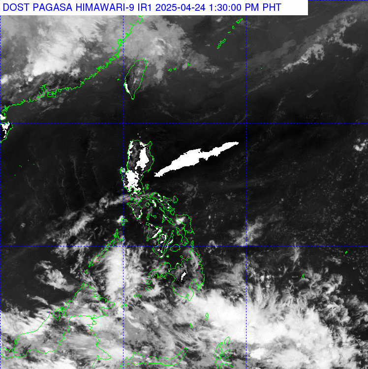
Synopsis
At 3:00 AM today, the center of Tropical Storm "CRISING" {WIPHA} was estimated based on all available data at 110 km West Northwest of Calayan, Cagayan (19.8°N, 120.6°E), with maximum sustained winds of 85 km/h near the center and gustiness of up to 115 km/h. It is moving West Northwestward at 25 km/h. Southwest Monsoon affecting Central and Southern Luzon, Visayas, and Mindanao.
Forecast Weather Conditions
| Place | Weather Condition | Caused By | Impacts |
|---|---|---|---|
| Batanes, Cagayan, Apayao, and Ilocos Norte | Stormy | TS Crising | Possible floods or landslides due to heavy to intense with at times torrential rains. Minor to moderate threat to life and property due to gale-force winds. |
| Isabela, Ilocos Sur, La Union, and the rest of Cordillera Administrative Region | Rains with gusty winds | TS Crising | Possible floods or landslides due to heavy to intense with at times torrential rains. Minimal to minor threat to life and property due to strong winds. |
| Metro Manila, Pangasinan, Zambales, Bataan, Cavite, Batangas, Occidental Mindoro, Palawan, Western Visayas, and Negros Island Region | Monsoon rains | Southwest Monsoon | Possible floods or landslides due to moderate to heavy with at times intense rains |
| Central Visayas, Zamboanga Peninsula, the rest of Cagayan Valley, the rest of Central Luzon, the rest of CALABARZON, and the rest of MIMAROPA | Occasional rains | Southwest Monsoon | Possible floods or landslides due to moderate to heavy rains |
| The rest of the country | Cloudy skies with scattered rains and thunderstorms | Southwest Monsoon | Possible flash floods or landslides due to moderate to at times heavy rains |
Forecast Wind and Coastal Water Conditions
| Place | Speed | Direction | Coastal Water |
|---|---|---|---|
| Extreme Northern Luzon | Strong to Gale | Southwest to Southeast | Rough to Very Rough / (3.7 to 5.5 meters) |
| The rest of Northern Luzon | Strong | Southwest to South | Rough / (2.8 to 4.0 meters) |
| The western section of Central Luzon, Southern Luzon, and Visayas | Moderate to Strong | Southwest | Moderate to Rough / (2.5 to 3.7 meters) |
| The rest of the country | Moderate to Strong | Southwest | Moderate to Rough / (1.5 to 2.8 meters) |
Temperature and Relative Humidity
Extremes for the 24-hour period ending at 8:00 PM YESTERDAY
(Recorded at PAGASA Weather Station, Science Garden, Diliman, Quezon City)
| Max | Min | |||
|---|---|---|---|---|
| Temperature (°C) | 27.5 °C | 3:00 PM | 25 °C | 1:40 AM |
| Relative Humidity (%) | 97 % | 2:00 AM | 85 % | 3:00 PM |
Tides and Astronomical Information
Over Metro Manila| Today | Tomorrow | ||||
|---|---|---|---|---|---|
| Astronomy | |||||
| Sun Rise | 5:36AM | -- | |||
| Sun Set | 6:29PM | -- | |||
| Moon Rise | -- | - | |||
| Moon Set | 1:02PM | -- | |||
| Illumination | 33% | -- | |||
|
Tidal Predictions for Manila Bay (m)
(Courtesy of NAMRIA) |
|||||
| High | 0.98 | 04:29AM | -- | -- | |
| Low | 0.43 | 11:54AM | -- | -- | |
| High | 0.55 | 04:52PM | -- | -- | |
| Low | 0.47 | 09:12PM | -- | -- | |
| High | -- | -- | -- | -- | |